Sunday 8 November 2015

Batu Punggul

We are planing to climb Batu Punggul in Sapulut in July 2016.

Sabah map

Climbing Batu Punggul

Below are some notes concerning this limestone hill as summarised from MySabah.com:-

1)  Height is 330m.

2)  Located in rainforest of Sapulut, 100km from Keningau.

3)  Sapulut is a land of the Murut tribes. We plan to stay at the Murut village.

4)  Starting point is Kampung Tataluan.

5)  10 minutes boat ride on Sapulut River to reach foothill.

6)  15 minutes walk from river side is the mouth of a cave.

7)  Another hill is Batu Tinahas about 20 minutes away from Batu Punggul. It has a more complex cave for hardcore hikers.

8)  The climb is around 1 hour route to the peak.

end of notes.

Thursday 5 November 2015

Travel Gallery

A collection of my travel photographs on momentary landscape. 


Monday 28 September 2015

Minduk Sirung Trail


We organised a group of 9 hikers to trek Gunung Alab jungle. It was a 12km trail called Minduk Sirung Trail that descended 1000m from its trail's peak of 2050m to Mahua waterfall in the district of Tambunan within the Crocker Range Park. The highest point of Minduk Sirung is at 2081m if according to the contour map. More information on the Crocker Range Park are described in MySabah.com (see links).


We trekked Minduk Sirung on 26th and 27th September 2015. Our trekking activities were slow and easy. The events were noted as below;

08:00  Traveled from Keningau to Mahua in Tambunan. We left our vehicles at Mahua station.

09:30  Traveled by taxis from Mahua to Gunung Alab station, the starting point of the 12km trail.

11:00  We started trekking. we were expecting the first 6km trail was to be an ascending trail to the peaks. The trail was usually wet. Two of our members unfortunately had leg cramps and needed to be cared for by the guide.

13:30  Reached a hut at 3.3km for lunch break. we then continued our ascending to the camping point.

17:00  Reached a camping ground at 6.0km. it is about 300m to the trail's peak. here we were fortunate to have water stream to fill up our bottles and for cooking. The two injured members reached here at 18:30 on lamps.


We played poker and consumed beers and wine to kill the night out. Surely there were leeches in the jungle. We sprayed Baygon around each camp's perimeter and on our boots to keep out the leeches;  that really worked.

07:00  We woke up to make breakfast. we had sandwiches and cups of noodle.

09:00  Continued our ascend to the peaks. The steepest ascending trail was at 8.0km, then it started to descend. There was a resting hut at 8.5km where water stream was also available. That was followed by another camping ground at 9.5km, but here the water source was dried at this time.


The descending trail was wonderful. We met numerous kinds of wild orchids, mushrooms and trees. We also encountered insect, snake and wild bird. There were bamboos and huge trees. A numbers of rafflesias were found at 10.5km. The largest tree can be seen at 11.0km.


Unfortunately our aim to catch the breathtaking views or sceneries from the peaks was dashed out by the haze due to the current Indonesian burning.


13:30 We reached the 12km finishing point at Mahua substation. Despite our tiring breaking muscles, we were welcomed by the soothing and cooling water fall at the finishing point. After we were satisfied by the water splashes, we took our late lunch at the local restaurant at about 15:00. Our two injured members reached here at 17:30, after then we drove home.

*********************************

How much does it cost?

1)  Permit fee    RM 30.00
2)  Guide fee     RM 80.00 per day (1-5 people)
3)  Porter fee     RM 8.00 per kg (RM25.00 add/day)

We spent about RM 200.00 per pax inclusive of all expenses such as food and logistic.

Any inquiry or arrangement regarding this trip can be made directly to the Crocker Range Park at 087-302011.

Friday 4 September 2015

Mount Trus Madi


On 26th June 2015, we formed a group of 15 hikers from Keningau to trek Nuluhon Trusmadi (Mt Trus Madi), the 2nd highest mountain of Malaysia, with its summit at 2,642m high. It is located in a forest conservation area in the interior districts of Sabah. There are 3 entry points, we chose to enter the forest reserve via Wayaan Kaingaran, Tambunan.

A detailed guide to Mt. Trus Madi was well described by Murphy on his website:
http://www.mysabah.com/wordpress/guide-to-climbing-mt-trusmadi/

Our hiking took place on 4th to 5th July 2015. The 2 day 1 night perfectly covered our travelling and trekking schedules as the following;

On the 4th July:
8:30  Travelled from Keningau to Tambunan by using 3 nos. 4WD vehicles.
9:30  Reached Tambunan town and picked up 3 mountain guides. We managed to grab quick breakfast.
11:00  Arrived at Kupu-Kupu gate for registration. Heavy storm came in. The road into the starting point was hampered by felt tree trunks. Heavy mist appeared throughout the way.


12:00  We had quick lunch at Mirai Irat river camp site.


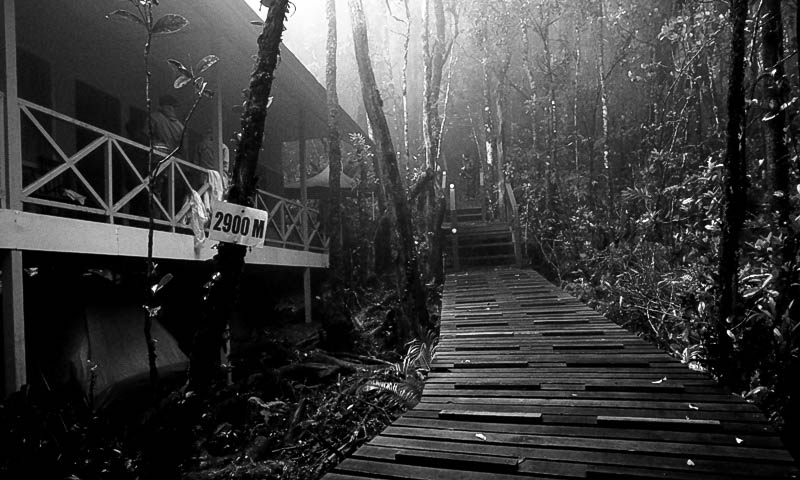
13:00  Arrived at the starting point.  We started trekking the 2km long boardwalk trail.


15:00  Reached a wooden rest house.  Everyone began to dry wet socks and wears. High humidity made drying impossible.
18:00  The guide made wonderful dinner for us. Rain continued throughout the night.


On the 5th July:
02:00  Morning call. The initial plan was to catch the sun rise at the peak.
02:30  We decided to cancel our initial plan due to persisting heavy rain. Some returned to bed.
03:30  Breakfast.
04:30  Began the remaining 3km jungle trek under considerate rain.

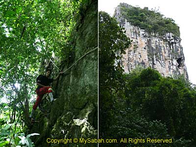
The wet weather added misty, slippery and challenging trail. There were several steep drops, ropes and ladders.


Several species of tropical pitcher plants were plenty in this rain forest.


08:00  The front group reached the peak.
09:00  The last group reached the peak. One gave up half way due to aches.
10:00  We started to descend to the rest house.
12:00  The front group reached the rest house and hungrily grabbed the prepared lunch.
13:30  The last group arrived at the rest house with light injury. We packed our belongings.
15:00  We continued to descend to the starting point.
17:00  Drove back to Keningau. We went home with a leech on a backpack!


Just as described by others, the trek was more like a "kampong road" if compared to the "highway" trail at Mount Kinabalu.

=================================================

How much does it cost?

As the area is managed by The Forestry Department, we applied the service of the Mount Trusmadi Travel & Tour agent in Tambunan. Their entry and service fees are as follows;

Payments to The Forestry Department, Tambunan
No
Particular
Fee
01.
Entrance Fee 
RM 2.00 (Adult)
RM 1.00 (Child)  
02.
Climbing Permit
RM 20.00 (Adult)
RM 10.00 (Child)
03.
Vehicle Permit
RM 100.00/Vehicle
04.
Climbing Certificate
RM 10.00/Pax

Payments to the Travel Agent
No
Particular
Fee
01.
Vehicle Rental
(From Tambunan-Starting Point)
RM 400.00/Vehicle/5Pax
(Max 7Pax)
02.
Guide
RM 160.00/5Pax/Trip
03.
*Resthouse
*Meal
*Insurance
RM 280.00/Pax

Payment to Porter RM 80.00 / 10 Kg below
If more than 10 Kg the additional charge is RM 8.00 / 1 Kg

We had spent about RM 430.00 per person for extra meats and beers.